Monday, December 30, 2013

Caterpillars Adapting to Climate Change

December 2013

Caterpillars Adapting to Climate Change

      In Colorado and California, two species of caterpillars have evolved to feed quickly at higher temperatures and at a wider range of temperatures over the past 40 years, suggesting that they are evolving rapidly to survive a hotter, more variable climate.
     Joel Kingsolver at UNC-Chapel Hill began work that represents an unusual instance of how recent climate change affects physiological traits, such as how the body regulates feeding behavior. Jessica Higgins, a graduate student in Kingsolver's lab led the study, working with fellow graduate student Heidi MacLean, Lauren Buckley, and Kingsolver to compare modern caterpillars to their ancestors from 40 years ago.
     Kingsolver said that this is so far the first instance that has shown changes in physiological traits in response to climate change. He also explains that Caterpillars can eat and grow only when it's not too cold and not too hot, but when temperatures are so ideal, caterpillars eat in unrestrained manner and can gain up to 20 percent of their body weight in an hour. That growth determines their ability to survive, how quickly they become adult butterflies, and their eventual reproductive success.
     Results show that the two related species of Colias (sulphur) butterflies have adapted in two ways. First, they extended the range of their ideal feeding temperatures. Second, they shifted their optimal feeding temperature to one that is higher.

     The researchers measured changes in climate at the two study sites and then examined changes in how fast caterpillars ate using current and historical data from the 1970s. Even though little change in the average air temperature at both study sites was discovered, it was noticed that the frequency of hot temperatures (exceed 82 degrees Fahrenheit) increased two-fold in Colorado and four-fold in California over the past 40 years. In response to these temperature fluctuations, today’s caterpillars in Colorado ate faster at higher temperatures than their 1970s counterparts. In California, the modern caterpillars ate faster at both high and low temperatures, but their optimal feeding temperatures did not change.

Lower Rio Grande Basin Water Supply

December 2013

Lower Rio Grande Basin Water Supply

     “Bureau of Reclamation Commissioner Michael L. Connor released the Lower Rio Grande Basin Study that evaluated the impacts of climate change on water demand and supply imbalances along the Rio Grande along the United States/Mexico border from Fort Quitman, Tex., to the Gulf of Mexico.”
     According to Commissioner Connor, this study will provide water managers with science-based tools to make important future decisions as they work to meet the region's diverse water needs. It will also help update water management discussions between the U.S. and Mexico through the International Boundary Water Commission.
     The study concludes that climate change is likely to result in increased temperatures, decreased precipitation and increased evapotranspiration. “As a result of climate change, a projected 86,438 acre-feet of water per year will need to be added to the 592,084 acre-feet per year of supply shortfall predicted in the existing regional planning process in 2060, for a total shortfall of 678,522.”
     Water supply disparities made worse by climate change will significantly reduce the dependability of distributions to all who are dependent on the Rio Grande’s water via irrigation deliveries.
     Seawater desalination, brackish groundwater desalination, reuse and fresh groundwater development were studied as alternatives to meet the future water demands. It was found that the brackish groundwater development was most suitable. “Next, an appraisal-level plan formulation and evaluation process was conducted to determine potential locations of each regional brackish groundwater desalination system.”

     The Lower Rio Grande Basin Study was established by Reclamation and the Rio Grande Regional Water Authority and its 53 member individuals. It was directed in association with the Texas Region M Planning Group, Texas Water Development Board, Texas Commission on Environmental Quality and International Boundary and Water Commission. It covered a total pf 122,400 square miles and cost $412,798 with the RGWRA paying for 52%.

Solar Activity and Climate Change

December 2013

Solar Activity and Climate Change

     A new scientific study shows the climate change has not been strongly influenced by variations in heat from the sun contrary to popular belief. This new discovery discounts the thought that lengthy periods of warm and cold weather in the past might have been caused by intermittent fluctuations in solar activity.
     Research investigating the causes of climate change in the northern hemisphere over the past 1000 years has shown that until the year 1800, the leader of periodic changes in climate was volcanic eruptions. Volcanic eruptions have a tendency to prevent sunlight from reaching Earth, causing cool, drier weather. But since 1900, greenhouse gases have been the primary cause of climate change. These findings prove that periods of low sun activity should not be expected to have a large impact on temperatures on Earth and should additionally help climate forecasting.

     
Scientists at the University of Edinburgh continued the study using records of past temperatures. They compared this data record with computer-based models of past climate, highlighting all changes in the sun. “They found that their model of weak changes in the sun gave the best correlation with temperature records, indicating that solar activity has had a minimal impact on temperature in the past millennium.”

How to Save Fiji's Coral Reefs

December 2013

How to Save Fiji's Coral Reefs

     “Thinking about the connections between the land and sea is rarely done when designing protected areas – Fiji is leading the way globally," said Dr. Carissa Klein, one of the many authors of the online edition of Marine Policy.
     Although many "managers" realize how downstream ecosystems such as coral reefs can be negatively affected by land-based activities, there have been few ‘on-the-ground’ cases where protected area networks have been designed using integrated planning to minimize external threats that cause increases in runoff and associated sediments, nutrients, and chemicals.
     The small island and developing state Fiji is just one example where selection of the locations of terrestrial protected areas have been based more on the cultural or timber value of forests than on protecting biodiversity. Fiji's current terrestrial protected areas cover less than 3 percent of land area in the country. However, these protected areas do not protect Fiji's sensitive island habitats and species or help minimize runoff to adjacent coral reefs.
     In 2008, a national Protected Area Committee was created by the Fiji government to achieve the goals of protecting 20 percent of the country's land and 30 percent of its coastal waters by the year 2020. The study authors contributed by systematically analyzing six scenarios for expanding Fiji's network of terrestrial protected area networks, with the aim to expose how well each approach would protect different forest types and minimize land-based runoff to downstream coral reefs. The study authors also recommended that some additional forests be added to their national register of priority places for protection.
     The committee took this advice and added additional forest areas to the final register of priority places for management endorsed by the Fiji government National Environment Council in October 2013.
     Dr. Caleb McClennen, director of the WCS Marine Program stated, "Their decision to take action and link land to sea conservation helps to ensure the long term security of their globally important coral reef ecosystems while supporting the livelihoods and resilience of coastal communities."

Saturday, November 30, 2013

Plants on the Moon

November 2013
Plants on the Moon

     NASA is teaming up with students and private space companies to grow the first plants on the moon’s surface starting in 2015. This self-contained Lunar Plant Growth Habitat will be similar to a "glorified coffee can" and will hold enough water, nutrients, and air to grow 1
0 turnip seeds, 10 basil seeds, and 100 arabidopsis seeds.
     "The experiment will test whether plants can survive radiation, flourish in partial gravity, and thrive in a small, controlled environment – the same obstacles that we will need to overcome in order to build a greenhouse on the Moon, or create life on Mars." If the seeds grow fruitfully, they will be the first Earth plant life sent to another terrestrial body.
     The article discusses how the "Lunar Greenhouse" will be built, and in order to test them, the team plans to send additional cans to classrooms across the country to see how the aluminum greenhouses perform in 'normal' terrestrial conditions. The article also explains what will theoretically happen once the mini-greenhouse is on the moon.
     The current price of this overall experiment is at a mere $2 million, due to the plan to hitchhike on the robotic spacecraft of whichever private company wins the Google Lunar X Prize, saving millions of dollars in travel costs. 

How Far Does Your Thanksgiving Turkey Travel?

November 2013
How Far Does Your Thanksgiving Turkey Travel?

     Each year millions of American families come together and feast upon the traditional dinner - a roasted turkey. From an environmental standpoint, it takes 14 units of fossil fuel to produce a serving of turkey compared to the 4:1 ratio for chicken and a 26:1 ratio for eggs (Cornell University).
     "The environmental impact of a turkey or any animal can be calculated two ways: the resources that went into raising it and the resources used to transport it to market." The production of the turkey makes up about 83 percent of the bird’s impact according to Columbia University’s Earth Institute. You can reduce the number of miles the turkey travels to the platter by purchasing from a local vendor, but this only reduces a small portion of emissions associated with the turkey. Therefore, what the individual farmer does in raising the bird has a greater impact than the buyer's decision to purchase locally.

China's Hazy Green Future

November 2013
China's Hazy Green Future

     China's densely polluted air normally makes the news with an emphasis on the public health aspect of the country, as opposed to the global warming angle. However, China’s reliance on coal is most definitely known.
     According to the article, there are signs that China is attempting to harness its smog problem by reducing its coal dependence. However, Christina Larsen reported several months ago in a Bloomberg story that this may not be so good for the planet. Although none of the newly proposed plants (converting coal to gas) are situated near China's large cities, the entire life cycle of harvesting coal and turning it into gas produces from 36 percent to 82 percent more total greenhouse gas emissions than burning coal directly 
     The article also mentions Slate’s Joshua Keating article about China's smog. He states that China's CO2 emissions are a much bigger problem than its smog. The article reports that China’s smog reduction plan could actually increase its emissions by moving to synthetic natural gas converted from coal, which burns cleaner than coal but produces more CO2 overall. Mr. Keating states that dealing with CO2 is going to be a much more difficult problem, and a much harder one to resolve with the country’s desire to maintain its fast pace of economic development.

United Nations Climate Meeting

November 2013

United Nations Climate Meeting 

     The Warsaw Climate Change Conference meetings in Poland ended November 23 with "a pair of last-minute deals" sustaining hope that a global effort can hold off a harmful rise in temperatures. This meeting's actions drove the talks about the possible United Nations 2015 conference in Paris to replace the moribund Kyoto Protocol.
     The 19th annual meeting of the United Nations Framework Convention on Climate Change started "in the shadow" of the giant Philippine typhoon. More than 10,000 people listened in on the talks, including national delegations, journalists, advocates and, for the first time, business leaders.
     At the meeting, delegates settled on the expansive outlines of "a proposed system for pledging emissions cuts" and extended their support for a novel treaty device to embark upon the "human cost of rising seas, floods, stronger storms and other expected effects of global warming."
     The death and devastation brought by the Philippine storm emphasized the question of “climate justice.” The final agreement was held up by a dispute over a proposal by developing nations for the creation of a “loss and damage mechanism” under the treaty. The United States, the European Union and other developed nations opposed, fearing new financial claims. However, Peace was restored when the parties overcame their differences, agreeing with the United States to hold the new device under an already existing part of the treaty dealing with adapting to climate change, but saying they would evaluate its status in 2016.
    In conclusion, treaty members remain far from any serious, concentrated action to cut emissions. In addition, developing nations complained that promises of financial help have still not been met.
   

Wednesday, October 30, 2013

Echolocation - Bats and Whales

October 2013

Echolocation of Bats and Whales

     Although bats and whales may seem very different, they both have developed the ability to use echolocation, or a biological sonar, for hunting. Danish researchers today show that the biosonar of toothed whales and bats are extremely similar, even though their environments differ and the two vary extremely in size. This is because through evolution, both bats and toothed whales have developed the same functional characteristics.
    Researchers from Aarhus University and University of Southern Denmark (Danish universities) are studying the "acoustic properties of the technique behind echolocation in bats and whales in the wild". These studies are providing a much more realistic picture of how the animals use echolocation in the wild.

     Professors of the universities say that the similarities of the two are because all mammalian ears are developed in quite similar ways, and "the contradicting physical conditions in air and water along with the differences in size of the animals even out the differences, that you would expect in the sound frequency".

     The researchers conclude that bats and toothed whales produce signals for echolocation in the same frequency range, from 10 to 200 kHz".

Earthworm Invasion

October 2013

Earth Worm Invasion

     Earthworms are being called the most recent keystone species to be added to the list for the forests of New England. Keystone species are groups that control an ecosystem and have a disproportionate impact on other species. Although none of the worms are native to the area, the migration of a few different species of earthworms is being tracked in attempt to understand how their soil-eating ways are affecting forests and global stocks of carbon. These earthworms are also being categorized as invasive species: non-native animals and plants, carried by people into new locations, that take hold, disrupting and reshaping local ecosystems.


     Scientists at the University of Vermont are reporting sixteen earthworm species reported in the state that are all exotic: fourteen are European and two are Asian. Many of these worms are invaders, spreading quietly underground. Although there is a good amount of carbon stored in trees aboveground, a roughly equal amount of carbon is stored belowground where these earthworms are. This is because the earthworms participate in decomposition underground, and release carbon dioxide as they eat. This adds to the forest's carbon emissions, which leads to the greenhouse effect and global warming. However, earthworms do a good job spreading soil aggregates that physically protect the organic carbon inside them, forming a barrier to the microorganisms that could otherwise break it down.

Coral Reefs and Climate Change

October 2013

Coral Reefs and Climate Change

     As a result of a study funded by the NOAA, coral reefs are improving their chances of surviving through the end of the century because they may be able to adapt to moderate climate warning if there are large reductions in carbon dioxide emissions. The study was conducted by the NOAA's scientists and its academic partners. A convincing result of the study shows that coral reefs have already adapted to part of the warming that has occurred. 


   As published in the Global Change Biology, the study explores a variety of possible coral adaptive responses to thermal stress previously identified by other scientists. It suggests that coral reefs may be more resilient than otherwise thought in studies that did not consider effects of possible adaptation. Through genetic adaptation, "the reefs could reduce their projected rate of temperature-induced bleaching by 20 to 80 percent of levels expected by the year 2100, if there are large reductions in carbon dioxide emissions".

Gold Mining Destroys Peru

October 2013

Gold Mining Destroys Peru

      In the biologically diverse region of Madre De Dios in the Peruvian Amazon, researchers have just now been able to map the true extent of gold mining. Led by Carnegie's Greg Asner and the officials from the Peruvian Ministry of Environment, the team used the Carnegie Landsat Analysis System-lite (CLASlite) to detect and map large and small mining operations. The team used field surveys and airborne mapping with high-resolution satellite monitoring to display that "the geographic extent of mining has increased 400% from 1999 to 2012 and that the average annual rate of forest loss has tripled since the Great Recession of 2008". The results of the tests performed showed a greater amount of rain-forest damage than that that was previously reported by the government, NGOs, and other researchers. "In all, we found that the rate of forest loss from gold mining accelerated from 5,350 acres (2,166 hectares) per year before 2008 to15,180 acres (6,145 hectares) each year after the 2008 global financial crisis that rocketed gold prices."
     Not only has the gold mining been destroying rain-forests, it releases sediment into rivers causing severe problems with the aquatic life. Peru's gold mining has also added to the widespread mercury pollution affecting the entire food chain, including the food ingested by people all over the region. "Miners also hunt wild game, depleting the rain-forest fauna around mining areas, and disrupting the ecological balance for centuries to come".
In the past, thousands of small, clandestine mines that have been successful since the economic crisis have operated unmonitored. 

Thursday, September 26, 2013

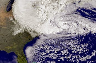
No More Super-storm Sandys


September 2013

Will Another Super-storm Sandy Come Again Soon?

     As last year's Hurricane Sandy is investigated more today, new simulations suggest that the atmospheric conditions that allowed the hurricane to follow its unusual path will become less frequent in the future. Typically, North Atlantic hurricanes travel roughly parallel to the East Coast and make landfall approaching from the south. The October 2012 storm that slammed New Jersey was an unusual occurrence because it took a left turn and approached from the east, hitting New Jersey at a right angle. This "nearly perpendicular angle to the shore intensified its destructive storm surge". 
Hurricane Sandy 2012
     "An analysis published in May found that, under current climate conditions, hurricanes like Sandy that hit New Jersey at a right angle occur on average once every 700 years".
     In order to understand how climate change might change atmospheric patterns and alter that frequency, Elizabeth Barnes, an atmospheric scientist at Colorado State University in Fort Collins, and her team ran simulations of an extreme warming situation where "carbon dioxide emissions quadruple over the 21st century". In agreement with Barnes is Thomas Knutson, a climate scientist at the National Oceanic and Atmospheric Administration’s Geophysical Fluid Dynamics Laboratory in Princeton, N.J., who says the results are “suggestive” that wind conditions favoring Sandy-like storms will decrease. 

Fracking in Ohio


September 2013

Is Fracking in Ohio Invading the Environment?

        A new study is examining methane and other components in groundwater wells before the start of possible drilling for shale gas that's expected to commence over the next several years in Carroll County, Ohio. Amy Townsend-Small of the University of Cincinnati and a team of UC researchers spent a year doing periodic testing of groundwater wells in  a section of Ohio that sits along the shale-rich Pennsylvania-West Virginia borders - Carroll County. The study was conducted to analyze 25 groundwater wells at different distances from proposed fracking sites in the "rural, Appalachian, Utica Shale region of Carroll County". Due to the area being so rural, many of its inhabitants rely on groundwater wells for their water supply. The samples, which are taken every three to four months, are analyzed for concentrations of methane as well as hydrocarbons (a carcinogenic compound) and salt, "which is pulled up in the fracking water mixture from the shales, which are actually ancient ocean sediments".
        Fracking, or hydraulic fracturing, is a process that uses millions of gallons of water mixed with sand and chemicals to break up the organic rich shale in order to produce natural gas resources. According to some,  
A drilling rig in Carroll County, Ohio. (Credit: Amy Townsend-Small)
fracking promises a future in "lower energy prices, cleaner energy, and additional jobs amid a frail economy". However, opponents express concerns about this fracking leading to increased methane gas levels (greenhouse gas) and other contamination. But, Townsend-Small explains that "some groundwater wells naturally hold a certain level of methane due to the decomposition of organic matter". Although it is not toxic drinking water, high levels of the methane can result in explosions.

Tuesday, September 24, 2013

"Pollutants From Plant Killed Fish in China"


September 2013

"Pollutants From Plant Killed Fish in China"


Along a 19 mile river in Hubei Province in central China, thousands of dead fish were found floating along the river, and about 110 tons of them have already been cleared. Environmental officials said these fish were killed by pollutants emitted by a local chemical plant. Environmental protection officials also said tests on water taken from the Fu River upstream from the metropolis of Wuhan showed that extremely high levels of ammonia in the water had been caused by pollution from a plant owned by the Hubei Shuanghuan Science and Technology Company. Officials then ordered the company’s plant to stop production while the cause of the leak was investigated.
     According to the local news media reports, the plant produces sodium carbonate and ammonium chloride for fertilizer. Since 2008, it has been cited for environmental violations four times, according to Ma Jun, director of the Institute of Public and Environmental Affairs, a Chinese nongovernmental organization that follows and researches air and water pollution.
     China’s Ministry of Environmental Protection says that water pollution was a serious concern in this case based on the factors of industrial spills, farm runoff, and untreated sewage in degrading water quality. The Fu River flows into the Yangtze, China’s longest river and a source of drinking water for millions. Mr. Ma explains that spills into the Yangtze and its tributaries continue to be a problem despite the many investments that  have been made in reducing pollution. 

Monday, September 23, 2013

The Mendenhall Glacier


September 2013

      Alaska Glacier Thaws Revealing Ancient Forest From Beneath
   
     Alaska's Mendenhall Glacier is revealing an ancient forest as it thaws. The Mendenhall Glacier, an icy expanse of 36.8 square miles, has withdrawn about 170 feet each year since 2005. In a thousand years, many tree stumps are now being exposed to the sunlight. About five feet of gravel most likely encased the bases of the trees when the glacier first advanced, keeping the stumps upright even as the glacier plowed over and snapped the stumps' trunks and limbs. Cathy Connor, an Alaskan geology professor, states, "There are a lot of them, and being in a growth position is exciting because we can see the outermost part of the tree and count back to see how old the tree was."  
Mendenhall Glacier in Juneau, Alaska 1990
Mendenhall Glacier, 2013